
Mapping and Visualisation

Location-based services for meaningful asset insights
Spatial information is often the one common element across all the data that asset-intensive organisations rely on to keep their businesses running. By using maps and visual representations, organisations can better understand and communicate relationships like the proximity of work crews to a site fault, or customers located within the area of an outage.
COSOL's Geographic Information System (GIS) experts help organisations establish location as the gateway to asset information, systems and processes. Working with technologies like Esri ArcGIS, Geocortex and FME, our team provides services ranging from solution design and architecture to platform implementation and support to help asset-intensive organisations leverage geographic information to generate meaningful location-based insights.
By adopting an asset information ecosystem view in combining GIS and asset management expertise through a single point of engagement, COSOL can architect solutions to support the intricate relationship between asset and location data while eliminating many common points of failure when GIS is addressed in isolation from asset management functions.
See locational services in action in our short videos:
Locate and Assign Work Orders
The below video is an example of how to locate, and assign work orders through maps using Maximo Spatial.
Retrieve Asset Information In The Field
Enable a mobile workforce to collect, access and process information in the field. This video demonstrates the retrieval of asset information and record asset condition reports during inspections.
Operations Dashboard
Maps are the gateway to asset management operations.
Identify The Impact Of Works
The video below show mapping being used in valve isolation for a water utility company.
When maintenance works require disconnection of water supply, visually identify the valves to be closed and communicate the outage to the public.
EXTRACT VALUE
Squeeze GIS to do more for the business by leveraging technical expertise to build, develop and maintain high-performing environments.
FIND EFFICIENCIES
Map asset data to visualise, explore and analyse spatial relationships to discover new ways of working.
RIGHT FIRST TIME
Secure GIS expertise to simplify GIS infrastructure and data. Maintain data standards to minimise errors, double-handling and rework.
EXTENDABLE
Embed GIS to modernise and extend business processes. Securely deliver data and workflows among internal and external stakeholders.
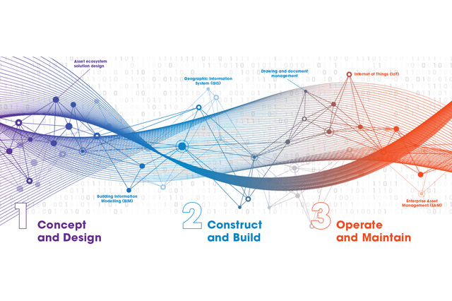
EAM SYSTEMS AND THE ASSET INFORMATION ECOSYSTEM
Learn more about integrating Enterprise Asset Management systems into the asset information ecosystem.